You are using an out of date browser. It may not display this or other websites correctly.
You should upgrade or use an alternative browser.
You should upgrade or use an alternative browser.
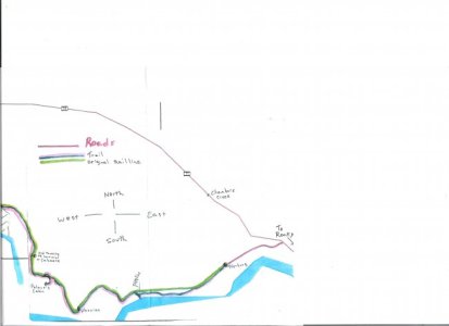
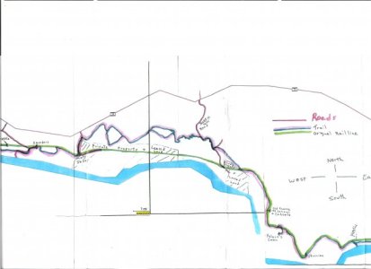
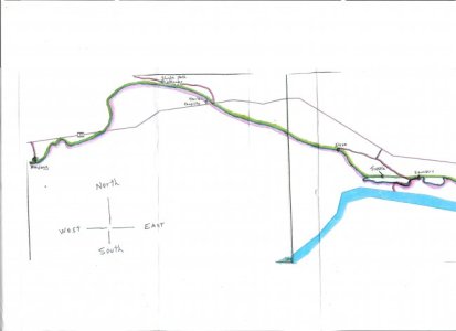
Map for Rocky to Nordegg trail,on railline.
- Thread starter hadster
- Start date
BIG_BRUTE750
Active VIP Member
yea i want to try that in the summer to a few from barrhead want to. 

medler
I love guns
I have been in contact with hadster and thinking about a month and half or better ,before Maylong anyway,I am sure he will respond to this post as well.
BIG_BRUTE750
Active VIP Member
month and a half before may long might be a little to much snow there for quads.

medler
I love guns
OOPS what i meant to say is in a month and a half or so we are planning a ride out there Sometime before the May long weekend anyway .We don;t have a date yet
- Thread starter
- #7
hadster
Active VIP Member
Yes as soon as the snow goes down enough to get up some of the steep hils etc. i've been going out in my truck often checking the snow pack depth, it's still very deep in the jackfish lake area. Of course we just got another big dump of snow last week. I'm hoping for sometime in early to mid April, but it's really up to mother nature, often she dissapoints.
Major
Active VIP Member
Are going to bring your quad this weekend Medler? Jody wants to show us how to climb the sand slide. I already went up there once dont need to again,but if it will shut him up I guess we will have to show him up. Lyle might come with us on may long too. havent decided if the rail ride will be the way to go or not. lets line up a day to go scout it out for some random camping spots.

medler
I love guns
10-4 Major
dustbuster
Member
Thanks for the map! I'm stoked to ride this trail this summer. About how long is the trail? I don't wanna run out of gas...
- Thread starter
- #11
hadster
Active VIP Member
Thanks for the map! I'm stoked to ride this trail this summer. About how long is the trail? I don't wanna run out of gas...
It is about 100 km or so all the way and will take about 8 hrs one way to do, so you may want to random camp about half way (the Jackfish lake area) and do it in 2 days, half at a time. In some areas it is challanging and you will need some experience to make it through, also some corners etc. are not marked properly so you could lose your way unless you have a good sense of direction & or a gps, etc.The markings you will follow will be signs that say "coalminers trail" or blue paint on trees with black arrows. You may notice there are 2 separate ways to go in a few spots, one will ussually be much wetter the other higher & dryer. Message me if you are planning it and i might be available to show you the way.
T-GUY1978
Active VIP Member
Hey me and a couple buddies are thinking of heading out there and staying at Horburg. I am just wondering where to camp around there. Any ideas? We are also looking to do a little fishing. Is there a way to get down to the North Saskatchewan and can you ride along side it?
- Thread starter
- #14
hadster
Active VIP Member
Yes in the Horburg area there are places to set up camp (random camping only, no services) along the way to the horburg boat launch etc. & on the way down that road there is a fork in it, if you keep right and follow the little trail in. Will be lots of standing water in the road, but it's not too deep and has a good bottom, as long as your'e on the right trail. There are some spots to go to the river (Horburg, straight south of Palmer's cabin,Saunder's boat launch, & just west of Saunder's area right where Taunton creek flows into the Sask. river) are some spots. The trail itself does not follow right along the bank all the way, most spots that it does you are high above the river.
RENEGADEGUY
Member
thanks for the map hadster my name is cody... me and a couple buddies were going to check it out let me know when you are going and we will meet you there

- Thread starter
- #16
hadster
Active VIP Member
thanks for the map hadster my name is cody... me and a couple buddies were going to check it out let me know when you are going and we will meet you there
Hey Cody there is a group of us going out for a ride, about the first half or so of the trail on Sat. April 18. It's in another posting on this same area if your'e interested.
Taz56
Active VIP Member
- Joined
- Dec 27, 2008
- Messages
- 167
- Reaction score
- 13
- Location
- Calgary Alberta
- Website
- www.56offsuit.com
Can anyone tewll me how many KM's of trail this is?
medler
I love guns
about 100 km or so give or take.about a 7-10 hour ride depending on conditions and breaks along the way
Similar threads
- Replies
- 2
- Views
- 784


