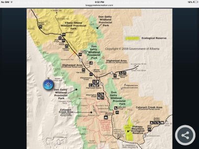
I do not believe there is a map, as there are no designated trails - yet, other than in the Willow Creek P.L.U.Z.Is there a map of this area? Seems to be in between Cataract and Crowsnest area
You are using an out of date browser. It may not display this or other websites correctly.
You should upgrade or use an alternative browser.
You should upgrade or use an alternative browser.
MacLean Mountain Riding
- Thread starter thejean
- Start date
JZ1
Active VIP Member
BTW - Change is coming with regards to the Alberta backcountry, so my government contacts tell me. The public will not be consulted, they will just appear - at this point.
Change as in shutting down areas?
what does the bolded mean?
BTW - Change is coming with regards to the Alberta backcountry, so my government contacts tell me. The public will not be consulted, they will just appear - at this point.
So how do we fight an enemy when we can't see what they're doing?
JZ1
Active VIP Member
So how do we fight an enemy when we can't see what they're doing?
Its a unwinnable fight against our lovely NDP gov. Just think only 3 1/2 more years of that no good $%^&
Not necessarily shutting down areas, but may be shutting down trails that have been traveled by quad for quite some time. I can guarantee you that trails will be moved - if not shutdown - through "wet zones"; marshes, ponds, stagnant water - from what I am hearing.Change as in shutting down areas?
what does the bolded mean?
The consulting being done currently is through organized and recognized groups; individual members of the public are not involved. So if you are not involved in a club, or starting one and getting recognition, you will not hear anything. I, personally, spend quite a bit of time keeping myself informed for the Calgary Snowmobile Club and its' members, to represent their interests.
I would suggest to everyone to stop complaining about membership dues for clubs and join one, or start your own. I do not get paid for what I do, but do it so that we do not loose access to the backcountry for snowmobiles at Cataract Creek and "the Green Zone" of public lands.
Easy - get involved on a personal level, educate yourself as to what is happening as I have, join an organized group that will represent your views, or start your own club.So how do we fight an enemy when we can't see what they're doing?
I would beg to differ with you here. Anyone that knows me knows I have no love for the NDP, as I come from Saskatchewan before my friend Brad Wall became Premier.Its a unwinnable fight against our lovely NDP gov. Just think only 3 1/2 more years of that no good $%^&
There are some "things" that the provincial PC's chose not to address when in power, trails and trails management outside of Provincial Parks was one of them. From what I have heard this will now be addressed, as the legal requirements of the South Saskatchewan Regional Plan require it. It sounds like new regulation will be out the first quarter of 2017, latest.
Easy - get involved on a personal level, educate yourself as to what is happening as I have, join an organized group that will represent your views, or start your own club.
Does S&M not count as an organized group? Maybe we need to change how we go about this. Members 51,827 strong...
Does S&M not count as an organized group? Maybe we need to change how we go about this. Members51,827 strong...
Sadly, no it does not. S & M is a website.
- Thread starter
- #30
So as OP, I'll answer a few things...
No, I likely will not try to change the regs in Alberta but rather, I'll just continue riding in BC. Or if I get laid off I'll just move there. The reason is not that I don't care but rather, the areas here are apparently not worth fighting for. Not enough snow and still hours away anyway. If I could drive due west of south Calgary and ride in Kananaskis, I would consider it. But the chances of that happening are zero. I'll continue to spend my spare time driving to, and spending my money in, BC.
No snowbikes in Cataract? Really? Who in the hell in their right mind would enforce that? So what the hell is a snowhawk then? (Anger not directed at the poster but by the sheer stupidity of the Reg FYI.) I have ridden out there. Cop came by, asked us about our bikes and how we liked them and then told us to have a great ride. So clearly that rule is not being enforced. But regardless that trail over Fording is just a pain anyway. I'd rather go a little farther to Crowsnest.
And I am very interested in this area at chain lakes. Even if it's just access to the BC side from AB then I would be ok with that. Will look into it some more.
Lastly, thanks to those who gave their opinion of Maclean riding. Kind of what I figured. I was hoping there would be a few good meadows but apparently not. As for riding off trail, there is no way a snowbike will ever do the kind of damage a quad or dirt bike does out there. Ask me how I know - I have one of each of those also. Sometimes I wonder if the people who make up these regs have actually ever even seen these machines, let alone ridden one themselves! Brutal.
Last edited:
JZ1
Active VIP Member
so this area just north west of chain lakes, is there anywhere around there that is off limits? is the 532 a dead ended where it meets th trunk road? Might have to take a drive and check it out
- Thread starter
- #32
so this area just north west of chain lakes, is there anywhere around there that is off limits? is the 532 a dead ended where it meets th trunk road? Might have to take a drive and check it out
I can't find it on the map either. Looks like 533 just goes to cataract creek. Much easier to get there off the 40.
JZ1
Active VIP Member
I can't find it on the map either. Looks like 533 just goes to cataract creek. Much easier to get there off the 40.
Hiway 532 is on the north side of chain lakes and heads west and meets up with hiway 40(940). There is a looked gate at the cataract staging area, you can not go any further south on the 40(940)
So as OP, I'll answer a few things...
No, I likely will not try to change the regs in Alberta but rather, I'll just continue riding in BC. Or if I get laid off I'll just move there. The reason is not that I don't care but rather, the areas here are apparently not worth fighting for. Not enough snow and still hours away anyway. If I could drive due west of south Calgary and ride in Kananaskis, I would consider it. But the chances of that happening are zero. I'll continue to spend my spare time driving to, and spending my money in, BC.
No snowbikes in Cataract? Really? Who in the hell in their right mind would enforce that? So what the hell is a snowhawk then? (Anger not directed at the poster but by the sheer stupidity of the Reg FYI.) I have ridden out there. Cop came by, asked us about our bikes and how we liked them and then told us to have a great ride. So clearly that rule is not being enforced. But regardless that trail over Fording is just a pain anyway. I'd rather go a little farther to Crowsnest.
And I am very interested in this area at chain lakes. Even if it's just access to the BC side from AB then I would be ok with that. Will look into it some more.
Lastly, thanks to those who gave their opinion of Maclean riding. Kind of what I figured. I was hoping there would be a few good meadows but apparently not. As for riding off trail, there is no way a snowbike will ever do the kind of damage a quad or dirt bike does out there. Ask me how I know - I have one of each of those also. Sometimes I wonder if the people who make up these regs have actually ever even seen these machines, let alone ridden one themselves! Brutal.
Excellent post thejean, I feel your pain! I sledded in BC for over 7 years exclusively before, over the need to insure a sled to ride public land in AB. It has been awhile since this time, and my situation has changed. I now ride almost always @ Cataract, maintaining and grooming the trails there, but still make it out to Crowsnest Pass and Golden on occasion for fun. On a side note, I have posted before - else where - that the the CO's rarely enforce the law on public land, unless they see something so over the line that they "have to".
Hiway 532 is on the north side of chain lakes and heads west and meets up with hiway 40(940). There is a looked gate at the cataract staging area, you can not go any further south on the 40(940)
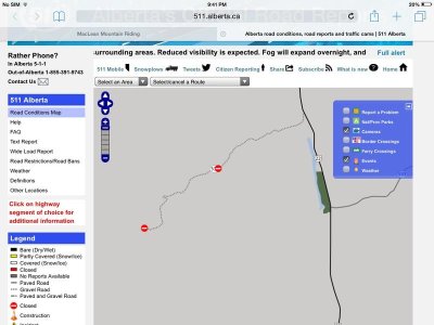
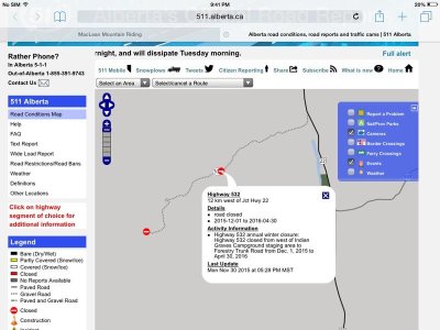
JZ1, Highway 532 has a locked gate on it just west of Willow Creek, before the road climbs any significant elevation away from the creek. This gate is not opened until April 30, 2016.
JZ1
Active VIP Member
JZ1
Active VIP Member
So in my above pictures is the Indian graves staging area at the first road closer on the 532 heading west?
JZ1
Active VIP Member
You are correct.So in my above pictures is the Indian graves staging area at the first road closer on the 532 heading west?
The the area off the 532 that I've been asking about is basically the furthest southern end of Cataract creek. So what/where is off limitssouth of hiway 532, how far west can you go?
First off, Highway 532 climbs to the west from Highway 22 - to the west of Willow Creek - through what I have been told is "Windy Pass", and joins up with Highway 940. As you know now, Highway 532 is now closed until May 1, 2016.
Highway 940 is closed at Cataract Creek parking lot until May 1, 2016.
Technically/legally - by regulation - one is not to ride anywhere in the Cataract Creek Snow Vehicle P.L.U.Z. where there is not trail, and you probably know this in not followed or enforced.
I am not sure if people unload at the parking lot beside closed gate on Highway 532, but I suspect they do. Someone who is local to High River, Longview, Nanton, or Claresholm would be able to better answer this.
Similar threads
- Replies
- 2
- Views
- 1K


