Iphone mapping and GPS

Stefan Plouffe

Active member
Joined
Nov 25, 2012
Messages
54
Reaction score
31
Location
Slave Lake AB
Does anybody use Iphone for mapping and finding out where you are?

I'm looking at many many apps that say they are all awesome but it seems like without cell coverage, your screwed.

How do GPS units get there mapping? Is there an app for Iphone that works? Like you can predownload areas or something?


Any thoughts?
 

Summiteer

Active VIP Member
Joined
Nov 8, 2006
Messages
5,883
Reaction score
3,508
Location
Whitecourt, Ab
The GPS receivers get their info straight from the Satellites. Pretty much need cell coverage to use an Iphone(one that still uses google maps not the apple 'get lost' mapping).
 

BeachSled

Active VIP Member
Joined
Apr 2, 2009
Messages
956
Reaction score
1,238
Location
Sherwood Park
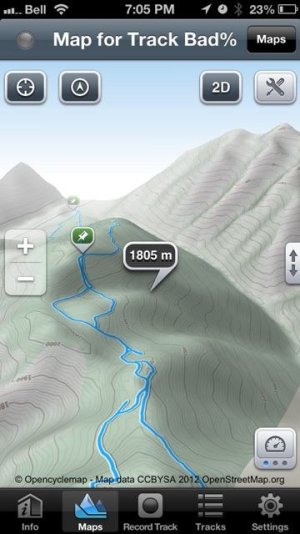
I used my iPhone on my last trip to valemount. I found Maps 3D & GPS Kit to be the best two out there. I found turning the cell data off made the phone last all day with no problems. It will get its GPS data from the satellites like any other GPS, I had no cell service all day and the GPS worked great for me. It will track just like a GPS would, save waypoints and anything else you would need. I liked maps 3D the best, it gives you the ability to rotate around the mountain and see what is on the other side or find your best way in and out.


Good luck


ImageUploadedByTapatalk1356746822.647526.jpg
 

BeachSled

Active VIP Member
Joined
Apr 2, 2009
Messages
956
Reaction score
1,238
Location
Sherwood Park
Nope no charge for GPS use, it is built into the phone and is not a "service" if you want to verify my findings. Get that pokey tool that came with the phone in the box and pop out the SIM card. You will then have no service at all. The phone will still GPS track. If you really wanted to, you can pre down load maps with one of those two apps and will be available in the app "off line" all i did was turn off the cellular data so the phone did not keep searching for service when there was none and the battery lasts even longer.

It works great !!
 

c_nelson99

Active member
Joined
Jul 12, 2009
Messages
97
Reaction score
170
Location
Edmonton, alberta
whats the name of that app and is it a free one? If you ever need to find oilfield lsd's try "rocanda land tracker" and "lsd nav light" free apps that work awesome. The lsd nav light will even tell you what the lsd is of your current location.
 

BeachSled

Active VIP Member
Joined
Apr 2, 2009
Messages
956
Reaction score
1,238
Location
Sherwood Park
Just open the App Store on your phone and search for the apps. These were the best two I could find and liked the most.

Maps 3D
GPS Kit
 

RGM

Active VIP Member
Joined
Nov 1, 2009
Messages
1,773
Reaction score
3,878
Location
Pemberton
Just installed the GAIA GPS app. A couple of things I like about it is you can download NRC Canada topo maps as well as goggle earth map and use them off line as well as switch back and forth between maps. Also has a scale on the screen. Can import and export tracks. I am also using the 12V adapter on my XM and keep my iphone plugged in inside a spare glove in the glove box. Works great.
 

K45

Active VIP Member
Joined
Dec 20, 2009
Messages
265
Reaction score
643
Location
Alberta
For the I-Phone just download SkiTracks there is a free one and one for 99 cents, pick snowmobiling and start track and it records all tracks with satelite image - needs no cell service to work.
Then email your track to yourself and it will open up in Google Earth so you can view it better or share if you want.
 

RGM

Active VIP Member
Joined
Nov 1, 2009
Messages
1,773
Reaction score
3,878
Location
Pemberton
I have ski tracks also, doesn't compare to Gaia GPS.
 

eClKaNdY

Active member
Joined
Nov 1, 2008
Messages
112
Reaction score
98
Location
calgary
use gps kit application a few time work great for having a rough idea where you are, but not really precise.. got lost in frisby in a withe out last year and was realying on this one to find my way out but found out if you stop for too long and turn phone around the gps screw up... and you end up making loop... overall its ok and nice to find terrain but wouldn't thrust it enough t just rely on it... proper gps still way to o
 
Top Bottom