Handheld GPS...... What would you buy?

TylerG

Super Mod Geek
Administrator
Moderator
Joined
Nov 7, 2006
Messages
31,527
Reaction score
29,397
Location
Parkland County
I've got a really old Garmin Etrex Vista that is no longer updateable and really doesn't play well with the new Garmin Software, I'm thinking I need to upgrade.

Looking for feedback on the best handheld units out there, mostly for flat land riding (snowmobile and ATV) and for hunting.
 

RXN

Active VIP Member
Joined
Feb 26, 2009
Messages
7,181
Reaction score
38,387
Location
Gibbons, Alberta, Canada
I went with an inreach and im pretty happy with it. Paired up with Earth Mate on my phone.

Yeah there is a subscription. I manage to use it year round.
 
  • Thread starter
  • Admin
  • #3

TylerG

Super Mod Geek
Administrator
Moderator
Joined
Nov 7, 2006
Messages
31,527
Reaction score
29,397
Location
Parkland County
I went with an inreach and im pretty happy with it. Paired up with Earth Mate on my phone.

Yeah there is a subscription. I manage to use it year round.
Isn't the inReach just a communicator? or do they have the ability to save way points etc right on them? I want to be able to load up from my computer using google earth way points, yes I know my cell phone will do it too, but want something more durable.
 

ABMax24

Active VIP Member
Joined
Sep 10, 2013
Messages
4,920
Reaction score
14,258
Location
Grande Prairie, Alberta, Canada
From my understanding the Garmin App is free and can be used without an inReach. It's my go to choice, it uses the GPS within my Google Pixel 4 so I don't even need to be paired with the inReach to use the GPS functionality, I will never own another GPS device now with this.

Go to your phones app store and search Earthmate App and download it. The key is you then need to go to settings and download the applicable maps to your area, I think I have all of western Canada downloaded to my phone.

Disregard that, the App is free, but looks like an inreach subscription is needed to use it.
 

RXN

Active VIP Member
Joined
Feb 26, 2009
Messages
7,181
Reaction score
38,387
Location
Gibbons, Alberta, Canada
Isn't the inReach just a communicator? or do they have the ability to save way points etc right on them? I want to be able to load up from my computer using google earth way points, yes I know my cell phone will do it too, but want something more durable.
I map with mine.
I save waypoints and tracks.
 

arff

Active VIP Member
Joined
Apr 21, 2009
Messages
142,927
Reaction score
56,596
Location
Leduc
New garmin gps has built in inreach
 
  • Recommends
Reactions: RXN

RXN

Active VIP Member
Joined
Feb 26, 2009
Messages
7,181
Reaction score
38,387
Location
Gibbons, Alberta, Canada
Screenshot_20211012-213848_Earthmate.jpg

When I'm using the App this is the screen I see.
I do find a GPS breadcrumbs better (I found that my track lines are close but not exact. Could be my settings. I may need to set it to ping tighter)
Screenshot_20211012-213829_Messenger.jpg


This is the view i can look at after. I have it linked to my Facebook. I can also share these tracks. Others can download them onto their GPSs

Screenshot_20211012-213751_Messenger.jpg


All the dots are after i set my ping intervals closer. The long lines were how it came. Which made it more difficult to use as a breadcrumb GPS (if that makes sense)
 

arff

Active VIP Member
Joined
Apr 21, 2009
Messages
142,927
Reaction score
56,596
Location
Leduc
I use both. In reach and gps
Really like inreach plus
 
  • Like
Reactions: RXN

fnDan

Active VIP Member
Joined
Dec 7, 2006
Messages
1,444
Reaction score
1,439
Location
Foothills
I'm always concerned about cell phone battery life when sledding and possible interference with my beacon. I have a Garmin Rino mounted on the handlebars of the sled and an InReach on the opposite side of my beacon. The batteries on these last for days. I can stop and look down at any time to see where I am or where I should be headed. I don't use the Inreach for nav.
I'd love to try out a Garmin Montana with InReach built in. The screen size would be so much better.
 

NoBrakes!

Active VIP Member
Joined
Nov 13, 2011
Messages
6,391
Reaction score
13,074
Location
Edmonton
Garmin rino 650 in the dash, Iphone plugged into the glove box USB with GAIA and Earthmate, Delorme Inreach device on in pack with a Baofeng UV5R. I know its not a perfect system, but it works.

If I left any one item at home, it would be the Rino, but it's just nice to see your friends on the map in the worst conditions.... BUT They have to update that position though, which if not done, the device is useless.

I have heard the new Montana screen isn't that good in the cold.... I wish Garmin would come out with a new Rino with Inreach....
 

ferniesnow

I'm doo-ing it!
Joined
Dec 2, 2008
Messages
113,037
Reaction score
87,061
Location
beautiful, downtown Salmon Arm, BC
Garmin rino 650 in the dash, Iphone plugged into the glove box USB with GAIA and Earthmate, Delorme Inreach device on in pack with a Baofeng UV5R. I know its not a perfect system, but it works.

If I left any one item at home, it would be the Rino, but it's just nice to see your friends on the map in the worst conditions.... BUT They have to update that position though, which if not done, the device is useless.

I have heard the new Montana screen isn't that good in the cold.... I wish Garmin would come out with a new Rino with Inreach....
Very similar to my setup. I actually prefer the GaiaGPS app (works on satellites and cell service is not required) for tracks, waypoints, etc.. I left behind all my buds with the Rinos, so I have it synced with a couple BCA's for the wife and I. Still always take the Rino650. My inReach is my surviving tool in case of trouble and that is all I use it for.
 

NoBrakes!

Active VIP Member
Joined
Nov 13, 2011
Messages
6,391
Reaction score
13,074
Location
Edmonton
Free GAIA is pretty detailed and if you do pay, there's ALOT more in the app.
 

X-it

Active VIP Member
Joined
Jan 8, 2007
Messages
7,959
Reaction score
18,224
Location
Prince George
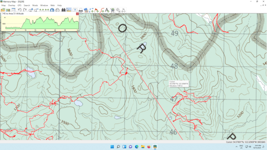
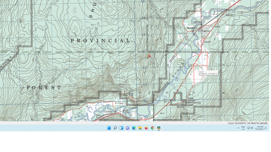
Magellan used to be good... software is crap now, get a garmin. I use memory maps on my tablet and phone...an amazing program but a large learning curve.
 

Attachments

  • gps.png
    gps.png
    1.1 MB · Views: 159

Ricki Bobby

Active VIP Member
Joined
Oct 21, 2015
Messages
974
Reaction score
1,922
Location
Sturgeon County
I really like my Garmin Montana with Backroads maps. I use it on the sled in the winter and on the Rzr in the summer.
 

X-it

Active VIP Member
Joined
Jan 8, 2007
Messages
7,959
Reaction score
18,224
Location
Prince George
For those interested this is what you would see.
 

Attachments

  • gps.png
    gps.png
    1.8 MB · Views: 216

earlskies

Active member
Joined
Oct 29, 2020
Messages
36
Reaction score
54
Location
Edmonton
Can someone explain the practical purpose of a dedicated GPS vs. using a cell phone with pre-downloaded maps? I currently use Gaia and carry a Sat-Phone.
 

X-it

Active VIP Member
Joined
Jan 8, 2007
Messages
7,959
Reaction score
18,224
Location
Prince George
Can someone explain the practical purpose of a dedicated GPS vs. using a cell phone with pre-downloaded maps? I currently use Gaia and carry a Sat-Phone.
A gps is a bit better at storing routes and downloading it to google earth and memory maps, plus it will place the picture on the exact spot it was taken. Bad thing is they have small screens. At one time google earth used to work on the phone...man that was awesome you could tell what tree you were standing beside it was so clear. It does not work now though.
 
Top Bottom