Crowsnest Pass Area

rubirose

Active VIP Member
Joined
Jul 27, 2008
Messages
1,196
Reaction score
593
Location
North of Stony Plain
Website
www.flickr.com
Hello all, we are planning on riding in the Crowsnest Pass area on our way back from riding north of Elkford, BC. I am not asking for your secret spots, but just general random camping areas with good hard pack trails, like at Grave Flats, Bighorn, Green bridge. We like to put miles on and see the scenery, not the bottom end of skeg fields. Any good info would be greatly appreciated by us. Thanks in advance. Oh yeah we dont want to end up in party spots.
 

arcticdodge

Active VIP Member
Joined
Nov 15, 2006
Messages
616
Reaction score
232
Location
Redcliff Alberta
There are lots of areas in the CNP. You can stage at atlas, or right in town at the ski-hill. Another area is by the Castle mountain ski hill. That's where I will be on the 30 of June. You can random camp up there and it is easy to get into to and has lots of beautiful scenery. Lots of trails. or you can leave from The Inn on the Border and go into Corbin. Check out the Crowsnest Pass Quad Squad site, it has exceelant maps and a wicked trail system.:d
 

rubirose

Active VIP Member
Joined
Jul 27, 2008
Messages
1,196
Reaction score
593
Location
North of Stony Plain
Website
www.flickr.com
There are lots of areas in the CNP. You can stage at atlas, or right in town at the ski-hill. Another area is by the Castle mountain ski hill. That's where I will be on the 30 of June. You can random camp up there and it is easy to get into to and has lots of beautiful scenery. Lots of trails. or you can leave from The Inn on the Border and go into Corbin. Check out the Crowsnest Pass Quad Squad site, it has exceelant maps and a wicked trail system.:d

I can't seem to find Castle Mountain ski hill on my map, could I get directions please. I found the Atlas staging area, if it is the snowmobile one, and did check out the quadsquad web site, very informative.
 

jaredszakacs

Active VIP Member
Joined
Mar 19, 2009
Messages
2,328
Reaction score
1,603
Location
pincher creek ab
I can't seem to find Castle Mountain ski hill on my map, could I get directions please. I found the Atlas staging area, if it is the snowmobile one, and did check out the quadsquad web site, very informative.

here is a very easy way to get to castle mountain area when you are travelling east on hwy 3 before the big weigh scales after the crowsnest pass take your first right it is called "hwy 507" this leads to beaver mines about 10-15 km up from were you turn right. continue on through the hamlet of beaver mines DO Not turn you will cross a bridge that will then hit gravel if U turn right before the gravel you will go to a place called castle falls this is the back trail system that will take you to the back of the crowsnest pass very good trail system lots of scenery and camping galour out there. Now back to castle MTN so continue across the bridge and hit the gravel road follow for another 10 km's and u will be at the base of the ski hill there are plenty of fields to camp in out there and a whack of trails with great scenic views if u need more info please pm me or grab the Kootenay backroad adventure map to find some great trails. Hope this info helps u out. Another nice area going to castle would be take a left just before the gravel and go to beavermines lake!!!
 

jaredszakacs

Active VIP Member
Joined
Mar 19, 2009
Messages
2,328
Reaction score
1,603
Location
pincher creek ab
yes that area has so many trails to ride wether it be all the way to the north into peter lougheed park or down south into waterton and akamina park I always so a pass mid july or august from fernie back over to the castle ski hill for lunch and a root beer minus the root and head back to fernie great ride but if u need any more trail info I can help and so can cnp quad squad
 

putang59

Member
Joined
May 10, 2010
Messages
12
Reaction score
4
Location
Medicine Hat, Alberta
As soon as it gets warm enough to tent camp and ride a dirtbike without a pile of mud then the staging areas like atlas and mcGilvery get full. Not a bad thing but, bikes usually mean a younger crowd who party and ride around at all times in the morning. It once was me as well, though not very smart, I tried to be respectful of others. The music to my ears is quite enjoyable but others such as my wife and small kids, not so much. Now if I camp at the staging areas I go early or late in the year. Or during the busy time I am a lot more selective on my location.
Another note. I was at Atlas Staging riding north of the hwy 3 fathers day weekend and the whole area was logged, or going to be logged. I could not believe it because it was one of the best places. And now it is not :(
 

rubirose

Active VIP Member
Joined
Jul 27, 2008
Messages
1,196
Reaction score
593
Location
North of Stony Plain
Website
www.flickr.com
As soon as it gets warm enough to tent camp and ride a dirtbike without a pile of mud then the staging areas like atlas and mcGilvery get full. Not a bad thing but, bikes usually mean a younger crowd who party and ride around at all times in the morning. It once was me as well, though not very smart, I tried to be respectful of others. The music to my ears is quite enjoyable but others such as my wife and small kids, not so much. Now if I camp at the staging areas I go early or late in the year. Or during the busy time I am a lot more selective on my location.
Another note. I was at Atlas Staging riding north of the hwy 3 fathers day weekend and the whole area was logged, or going to be logged. I could not believe it because it was one of the best places. And now it is not :(

Are there usually a lot of dirt bikes or is it still more quads? We are planning to be there during the last few days of July maybe the 28th, at least before the weekend. Do you know of less crowded staging areas or random camping areas that still access the trails? I don't like to camp where there are loud parties going on all the time, I do want to be able to sleep at night. If you have a secret spot that you don'e mind sharing you can send me a PM and it will not be shared by others. Thanks very much.
 

putang59

Member
Joined
May 10, 2010
Messages
12
Reaction score
4
Location
Medicine Hat, Alberta
Atlas is still your best bet if your early in the week because you can pick a site on the edge of the staging area with nice firepits and just tolerate the noise from a far. The CO's are usually around checking things out and keeping the headlightless bikes under control. Atlas road has some secluded spots right off the road if your rig can get to them that are quite nice. Mcgilvery is all staging area with no other options an really only a few trails to lead you to the rest. I like atlas because there are so many options for riding. I picked up a trail map from the local gas store which is a good detailed map of the area.
Some of the my favorite rides are

Aprox time 3-4 hours 50 km's intermediate
From atlas staging ride south to the fenced devon gas terminal, ride east on the open cut line through hills past the gun range, down the hill to the mcGilvery staging area. Head north past the summer camp all the way up the mountain. First marked y hang a right on 92. left, or straight goes up a wicked steep sled trail. Keep heading up the mountain crossing streams or bridges. Once all the way to the top and descending a bit there is a clearcut on the right and a trail on the left, go left on 93 and keep going. or instead of 93 ride a bit further and checkout another great view. Stay on the trail until you get to an atv bridge on the left cross the bridge and follow the trail/road past the discontinued mine all the way to the top of the mountain North. The trail is kind of steep but I made it covered in snow so summer should be fine. Wow what a view. Then turn around and go back to 93 turn off. eventually you make your way back to the atlas road or the trail that pars the road back to camp. There are a few good hills to climb and descend, and forced streams to cross with a UTV but all in all a really enjoyable ride, and good for a weiner roast half way.

2. Window Mountain 20 km 2hrs. beginner
Follow the atlas road down to km 7 on the map. (Straight east of the marked 97 sign on the pipeline trail.) Trails east to MT Ward/ Allison Peak Nice loop that brings you back out to the road. Bring your spotting scope because the waterfalls, Rockface, Mountain Sheep are well worth the ride and they are to far up to see clearly with the naked eye.

3. Plane Crash 3 Hours Advanced ??km's
This would be number 1 but coleman has a gay no quad rule in town and i have yet to figure out a way to ride the bikes to the south of the hwy 3 trail system from Atlas or McGilvery. If you want to do this trip you can stage south of coleman at york staging area. (not very much open space here for camping)
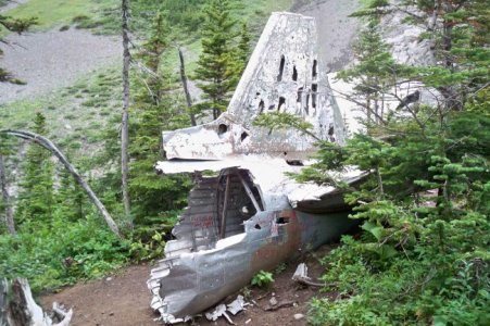
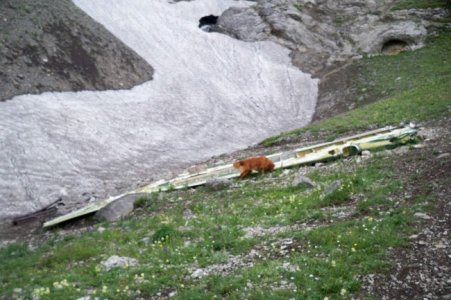
This ride is very cool because the plane that crashed is still there with a memorial of it. I would classify this ride as advanced because of the loose rock and steep climbs. My wife has made it up there with me riding here quad up some of the sketchy sections then walking down to pick mine up. Another spectacular view that most people will never have a chance to see.
Once on the trail system it is marked pretty well where to go. It is Just north of marker 44 head east, or east at marker 43. they both end up in the same place. At the start of june there was to much snow for us to get up there but end of july for sure you will make it.

My next trip if I don't find out a way to cross over the hwy 3 to york I am going to camp south of Blairmore closer to castle falls, I have not been there and heard it is nice and just as many trails.
 

rubirose

Active VIP Member
Joined
Jul 27, 2008
Messages
1,196
Reaction score
593
Location
North of Stony Plain
Website
www.flickr.com
Atlas is still your best bet if your early in the week because you can pick a site on the edge of the staging area with nice firepits and just tolerate the noise from a far. The CO's are usually around checking things out and keeping the headlightless bikes under control. Atlas road has some secluded spots right off the road if your rig can get to them that are quite nice. Mcgilvery is all staging area with no other options an really only a few trails to lead you to the rest. I like atlas because there are so many options for riding. I picked up a trail map from the local gas store which is a good detailed map of the area.
Some of the my favorite rides are

Aprox time 3-4 hours 50 km's intermediate
From atlas staging ride south to the fenced devon gas terminal, ride east on the open cut line through hills past the gun range, down the hill to the mcGilvery staging area. Head north past the summer camp all the way up the mountain. First marked y hang a right on 92. left, or straight goes up a wicked steep sled trail. Keep heading up the mountain crossing streams or bridges. Once all the way to the top and descending a bit there is a clearcut on the right and a trail on the left, go left on 93 and keep going. or instead of 93 ride a bit further and checkout another great view. Stay on the trail until you get to an atv bridge on the left cross the bridge and follow the trail/road past the discontinued mine all the way to the top of the mountain North. The trail is kind of steep but I made it covered in snow so summer should be fine. Wow what a view. Then turn around and go back to 93 turn off. eventually you make your way back to the atlas road or the trail that pars the road back to camp. There are a few good hills to climb and descend, and forced streams to cross with a UTV but all in all a really enjoyable ride, and good for a weiner roast half way.

2. Window Mountain 20 km 2hrs. beginner
Follow the atlas road down to km 7 on the map. (Straight east of the marked 97 sign on the pipeline trail.) Trails east to MT Ward/ Allison Peak Nice loop that brings you back out to the road. Bring your spotting scope because the waterfalls, Rockface, Mountain Sheep are well worth the ride and they are to far up to see clearly with the naked eye.

3. Plane Crash 3 Hours Advanced ??km's
This would be number 1 but coleman has a gay no quad rule in town and i have yet to figure out a way to ride the bikes to the south of the hwy 3 trail system from Atlas or McGilvery. If you want to do this trip you can stage south of coleman at york staging area. (not very much open space here for camping)
This ride is very cool because the plane that crashed is still there with a memorial of it. I would classify this ride as advanced because of the loose rock and steep climbs. My wife has made it up there with me riding here quad up some of the sketchy sections then walking down to pick mine up. Another spectacular view that most people will never have a chance to see.
Once on the trail system it is marked pretty well where to go. It is Just north of marker 44 head east, or east at marker 43. they both end up in the same place. At the start of june there was to much snow for us to get up there but end of july for sure you will make it.

My next trip if I don't find out a way to cross over the hwy 3 to york I am going to camp south of Blairmore closer to castle falls, I have not been there and heard it is nice and just as many trails.

We rode to the plane crash this past Tuesday morning. The trail has some tank traps on it up and down hill, take it slow and in low 4x4 when going up other than that nothing steep, not for real beginners but for people with some experience. The trail has had a cat go through it so it is very passable. There is no camping at the York staging area but we drove past that to the number 46(yellow bridge) and backed the truck and trailer down the trail for about a 100 yards and camped there for the one night. Not a road for big units, no camping further up the hill either.If you go please do NOT deface the plane parts that are lying about, some other idiots thought it would be nice to put graffiti on the tail section.
 

rubirose

Active VIP Member
Joined
Jul 27, 2008
Messages
1,196
Reaction score
593
Location
North of Stony Plain
Website
www.flickr.com
Here are just 2 of the photos of the wreckage.
 

Attachments

  • Tail-section,-copy.jpg
    Tail-section,-copy.jpg
    109.1 KB · Views: 341
  • Wing-section,-copy.jpg
    Wing-section,-copy.jpg
    77.6 KB · Views: 340

rubirose

Active VIP Member
Joined
Jul 27, 2008
Messages
1,196
Reaction score
593
Location
North of Stony Plain
Website
www.flickr.com
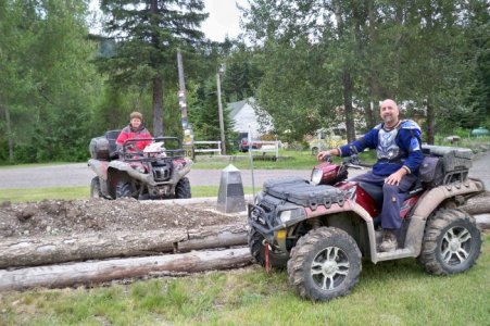
And we stopped in during a ride at the Inn on the Border and had a great talk with the owners(sorry forgot your names). They gave us great info on the trails in the area and gave us maps, bought the Quadsquad map of the trail system too. For you sledders especially I highly recommend staying here, there are soooo many places to ride and the scenery is awesome, the atv trails are also great, very easy to do and more than enough to keep you busy for a few days. Here is a photo in the front yard. Dean is in BC and I am in Alberta, by the survey post.
 

Attachments

  • AB-BC-border.jpg
    AB-BC-border.jpg
    105.8 KB · Views: 351

putang59

Member
Joined
May 10, 2010
Messages
12
Reaction score
4
Location
Medicine Hat, Alberta
It is a pretty long hike. I did it by accident and ran out of gas by sparwood. Cost me 100 in cab fair but better than a night in the bush. Where exactly do you want to start and finish?
 

d mills

Active VIP Member
Joined
Nov 10, 2009
Messages
3,275
Reaction score
4,982
Location
camrose
It is a pretty long hike. I did it by accident and ran out of gas by sparwood. Cost me 100 in cab fair but better than a night in the bush. Where exactly do you want to start and finish?

Thats awesome......those always make for the best riding stories....
 
Top Bottom