Baseline lookout tower

AB RANGER 007

Active VIP Member
Joined
Aug 1, 2008
Messages
451
Reaction score
201
Location
Vilna, AB,
I have come across that telagragh line out by Rough Creek it is real hard to find,,,, is there any mapping of that line????

SG, would you have any GPS Lat/LONG'S on the towers and the Telegragh Line area by Rough Creek??? need a place to start Software/air photo searching.:please:
I use Garmin GPS and MapSource Software, ibycus and Discover Canada (first ver.)

Bruce.:ranger:
 

Snogix

Member
Joined
Oct 25, 2007
Messages
12
Reaction score
0
Location
Edmonton
Website
www.derrickdodge.com
I know this was all posted last year but i'm going to resurrect the thread.

I'm assuming the GPS coordinates of N52 04.615 W115 21.273 are for the tower. But where would you stage? Where can you drive the trucks to and jump on the quads?

This looks like it would be an awesome ride and great photo taking oppurtunity.
 

sumx54

Active VIP Member
Joined
Oct 5, 2007
Messages
5,479
Reaction score
5,702
Location
Rocky Mountain House
Website
www.absoluteadventure.ca
You can stage right from #752 at the bottom of the tower road or any where you like for that matter. Once you actually drive out there you will see literally hundreds of trails to ride. Just park the truck and GO!! Have fun. :beer: :d
 

Orrin

Active VIP Member
Joined
Jan 26, 2009
Messages
1,532
Reaction score
36
Location
Near Chestermere
If you get the Fall Creek use only the prebuilt creek crossings, this area is under heavy pressure to be closed, the more damage there is to the fishery the better the chance that it will be.
 

Safari Guy

Active VIP Member
Joined
Mar 24, 2007
Messages
404
Reaction score
8
Location
Rocky Mountain House, AB
Website
www.wildkakwasafari.com
there is pre built crossings??? dont remember them,,,,,,,, just holes and hazzards,,,,,,, there is talk of saving falls creek area and making it a designated trail,, but have not heard lately. Every year a group of us go out and reserect a trail that has become non-ridable and this year we are going out in the 1st or 2nd weekend in May.
 

Orrin

Active VIP Member
Joined
Jan 26, 2009
Messages
1,532
Reaction score
36
Location
Near Chestermere
there is pre built crossings??? dont remember them,,,,,,,, just holes and hazzards,,,,,,, there is talk of saving falls creek area and making it a designated trail,, but have not heard lately. Every year a group of us go out and reserect a trail that has become non-ridable and this year we are going out in the 1st or 2nd weekend in May.

I used to help Wes Hansen and the Fall Creek Greenkeepers society, we re- routed the trail and got rid of about a dozen crossings and built a few bridges including the one to the springs that got moved in the flood a few years ago. I haven't been involved or in the area for a while now so maybe it all got wrecked or changed. Wes was the trail steward for the area and put a lot of his own time, money and effort in keeping the area rideable including building the existing campground at the blue bridge. I wonder if he still is involved?
 

99summitx

Active VIP Member
Joined
Apr 21, 2007
Messages
1,650
Reaction score
106
Location
Red Deer AB
there is pre built crossings??? dont remember them,,,,,,,, just holes and hazzards,,,,,,, there is talk of saving falls creek area and making it a designated trail,, but have not heard lately. Every year a group of us go out and reserect a trail that has become non-ridable and this year we are going out in the 1st or 2nd weekend in May.

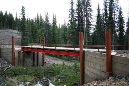
The only bridge I've found is the Northrock bridge and found it a very tight fit for the Teryx
 

Attachments

  • June 21 Trail survey 003.jpg
    June 21 Trail survey 003.jpg
    79.8 KB · Views: 131

Orrin

Active VIP Member
Joined
Jan 26, 2009
Messages
1,532
Reaction score
36
Location
Near Chestermere
yes i can see crossing under that bridge may be a little tight for the old kawi

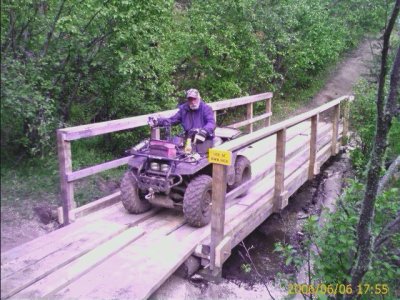
I didn't help with these but they are listed on the Fall Creek Conservation Society website. They are out there somewhere, or got wrecked in a flood, looks like it's time to revisit my old quadding trails.

Edit: I could only upload one pic here's the link to the other. Projects
 

Attachments

  • bridge%202.jpg
    bridge%202.jpg
    113.2 KB · Views: 130

sumx54

Active VIP Member
Joined
Oct 5, 2007
Messages
5,479
Reaction score
5,702
Location
Rocky Mountain House
Website
www.absoluteadventure.ca
I didn't help with these but they are listed on the Fall Creek Conservation Society website. They are out there somewhere, or got wrecked in a flood, looks like it's time to revisit my old quadding trails.

Edit: I could only upload one pic here's the link to the other. Projects

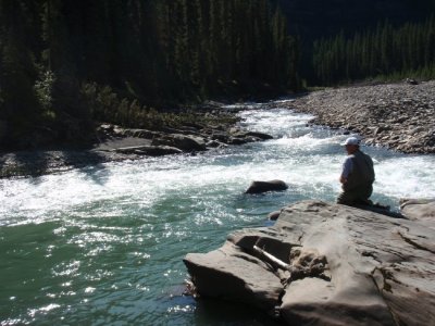
This bridge in your picture is still in good shape... some of the trail to the north is getting banged up though. I try and put in at least two or three days out that way fixing trail. For the most part people have been good at cleaning up after themselves better over the past 5-6 years. Have you ever drowned a hook in this hole out there?
 

Attachments

  • The fishing trip 044.jpg
    The fishing trip 044.jpg
    85.8 KB · Views: 142

Orrin

Active VIP Member
Joined
Jan 26, 2009
Messages
1,532
Reaction score
36
Location
Near Chestermere
This bridge in your picture is still in good shape... some of the trail to the north is getting banged up though. I try and put in at least two or three days out that way fixing trail. For the most part people have been good at cleaning up after themselves better over the past 5-6 years. Have you ever drowned a hook in this hole out there?

No I haven't, sure would like to.
 

250mark1

Active VIP Member
Joined
Dec 17, 2007
Messages
1,246
Reaction score
1,351
Location
blackfalds
i think the wooden bridge in the picture is north of the falls right after you cross over the sunpine mainline heading east towards the powerlines
 

AB RANGER 007

Active VIP Member
Joined
Aug 1, 2008
Messages
451
Reaction score
201
Location
Vilna, AB,
Thanks, 99 Summitx, but I have never been out there, and I working with mapping software that does not have this information on it. No Falls Creek Camp Ground, No Road. I have a page of information from the Fall Creek Conservation Society that list the Lat/Long of what is referred to as Bridge#1 and Bridge #3. No # 2 and no #4 witch is the Northrock Trail ATV bridge.

Bruce.
 

99summitx

Active VIP Member
Joined
Apr 21, 2007
Messages
1,650
Reaction score
106
Location
Red Deer AB
Thanks, 99 Summitx, but I have never been out there, and I working with mapping software that does not have this information on it. No Falls Creek Camp Ground, No Road. I have a page of information from the Fall Creek Conservation Society that list the Lat/Long of what is referred to as Bridge#1 and Bridge #3. No # 2 and no #4 witch is the Northrock Trail ATV bridge.

Bruce.

N52 08.281 W115 27.929 Falls cr road off Sec752, N52 10.844 W115 35.145 Falls cr campground hope this helps:beer:

What mapping software are you using? Ibycus2.1 & 3.0 and Topo CanadaV4 not V2 have the road shown. None show the campground.
 

sumx54

Active VIP Member
Joined
Oct 5, 2007
Messages
5,479
Reaction score
5,702
Location
Rocky Mountain House
Website
www.absoluteadventure.ca
N52 08.281 W115 27.929 Falls cr road off Sec752, N52 10.844 W115 35.145 Falls cr campground hope this helps:beer:

What mapping software are you using? Ibycus2.1 & 3.0 and Topo CanadaV4 not V2 have the road shown. None show the campground.

The road past the campground only goes up to the very first lease now. They reclaimed it all past that and it is almost impassable. The oil company did not leave any of the existing trail system that shared access with them. This all happened last fall... I'll post pics later. Maybe you already knew this... just sayin'
There is a couple of alternative routes in there but not for beginner riders.
Anywho...did we ever high jack the chit out of this thread :eek: :d
 
Top Bottom