avy in corbin any info

Marley

Active VIP Member
Joined
Dec 20, 2011
Messages
493
Reaction score
341
Location
SW Alberta & SE BC
My condolances to the family and friends of Steve.
I fail to understand the importance of questioning and trying to get the exact location of this unfortunate event. We all know it was in the Corbin area.
More information will come out as time passes by.
At this time I believe we should accept the information as it is, and allow the family and friends time grieve and heal from this terrible time in their life

What I would like to see is a downloadable database (for GPS units) of locations of past incidents and also well known avalanche locations. Even if you had to pay for the download and the money went to funding the CAC. Planning your ride would then be easier and it would also be a reminder of the dangers. Make it so users can also upload or otherwise add to the DB as they see slides in their travels.
If you always look at your GPS before doing a climb or passing through an area then you would have additional info to make decisions. I also think that high probability avalanche areas in the common riding areas should also have signage put up by the local club as another way to keep the danger in the forefront of peoples minds. CAC bulletins are great but more localized specific info is always good to have.
 

Modman

Active VIP Member
Joined
Mar 13, 2008
Messages
6,040
Reaction score
8,523
Location
Castlegar
I fail to understand the importance of questioning and trying to get the exact location of this unfortunate event. We all know it was in the Corbin area.
More information will come out as time passes by.
At this time I believe we should accept the information as it is, and allow the family and friends time grieve and heal from this terrible time in their life

well mainly I'm asking because there are comflicting stories and co-ordinates. The CAC report lists it as BC but the co-ordinates put the location on a south facing aspect in the Middle Kootenay Pass near Castle, which isn't BC and also might be exposing other people to risk. I know guys that ride down there (me included) and I want to be sure to tell them what hill has slid in the past and to stay away from it. I don't know why people are so scared to talk about it, it never seems like people want to talk about it, just shroud it and hide it away. As others have said, I meant no disrespect the to family or friends of this sledder.

I've personally known 3 people who died while sledding, I've been there too and saying it sucks does not even come close. It's tragic and we all support the family, whether you believe in he died doing what he loved, living life to the fullest, or in higher powers and this was God's will , the fact is he is gone, if we hide it then no one learns from this senseless tragedy. I like to think that his life is much more valuable than that and I'm sure his family and friends do as well.
 
Last edited:

HRT Offroad

Active VIP Member
Joined
Jan 2, 2008
Messages
812
Reaction score
1,099
Location
Kimberley, BC
well mainly I'm asking because there are comflicting stories and co-ordinates. The CAC report lists it as BC but the co-ordinates put the location on a south facing aspect in the Middle Kootenay Pass near Castle, which isn't BC and also might be exposing other people to risk. I know guys that ride down there (me included) and I want to be sure to tell them what hill has slid in the past and to stay away from it. I don't know why people are so scared to talk about it, it never seems like people want to talk about it, just shroud it and hide it away. As others have said, I meant no disrespect the to family or friends of this sledder.

I've personally known 3 people who died while sledding, I've been there too and saying it sucks does not even come close. It's tragic and we all support the family, whether you believe in he died doing what he loved, living life to the fullest, or in higher powers and this was God's will , the fact is he is gone, if we hide it then no one learns from this senseless tragedy. I like to think that his life is much more valuable than that and I'm sure his family and friends do as well.

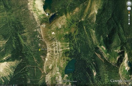
My results on Google Earth were no where near Middle Kootenay Pass, but just over the NW ridge above Barnes lake towards the pipeline??
 

Summiteer

Active VIP Member
Joined
Nov 8, 2006
Messages
5,883
Reaction score
3,508
Location
Whitecourt, Ab
What I would like to see is a downloadable database (for GPS units) of locations of past incidents and also well known avalanche locations. Even if you had to pay for the download and the money went to funding the CAC. Planning your ride would then be easier and it would also be a reminder of the dangers. Make it so users can also upload or otherwise add to the DB as they see slides in their travels.
If you always look at your GPS before doing a climb or passing through an area then you would have additional info to make decisions. I also think that high probability avalanche areas in the common riding areas should also have signage put up by the local club as another way to keep the danger in the forefront of peoples minds. CAC bulletins are great but more localized specific info is always good to have.
All it takes is money. Call your MP and MLA and get them to increase funding for the CAC. Or better yet, send in a cheque.
 

imdoo'n

Active VIP Member
Joined
Jan 15, 2008
Messages
58,747
Reaction score
52,281
Location
alberta from the back porch
i'd say any area that is open on a slope or through the trees has slid and will slide, given the right conditions. those conditions seem to exist right now.
 

Marley

Active VIP Member
Joined
Dec 20, 2011
Messages
493
Reaction score
341
Location
SW Alberta & SE BC
All it takes is money. Call your MP and MLA and get them to increase funding for the CAC. Or better yet, send in a cheque.

A downloadable database of coordinates would not cost CAC virtually any money - they have the info and the servers to do it. It would be a way for the CAC to raise money.
 

snopro

Active VIP Member
Joined
Mar 3, 2009
Messages
109,981
Reaction score
108,932
Location
Milo,Alberta
What I would like to see is a downloadable database (for GPS units) of locations of past incidents and also well known avalanche locations. Even if you had to pay for the download and the money went to funding the CAC. Planning your ride would then be easier and it would also be a reminder of the dangers. Make it so users can also upload or otherwise add to the DB as they see slides in their travels.
If you always look at your GPS before doing a climb or passing through an area then you would have additional info to make decisions. I also think that high probability avalanche areas in the common riding areas should also have signage put up by the local club as another way to keep the danger in the forefront of peoples minds. CAC bulletins are great but more localized specific info is always good to have.
I like where you are headed with this idea. A bad hill is like a leopard. You can't change its spots. If a hill is prone to slide more than others and there have been people involved in slides on it I sure would like that info if I'm riding in that area. After all its all about saving lifes.
 

Vertical-Extreme

Active VIP Member
Joined
Oct 29, 2008
Messages
612
Reaction score
636
Location
Airdrie Ab
well mainly I'm asking because there are comflicting stories and co-ordinates. The CAC report lists it as BC but the co-ordinates put the location on a south facing aspect in the Middle Kootenay Pass near Castle, which isn't BC and also might be exposing other people to risk. I know guys that ride down there (me included) and I want to be sure to tell them what hill has slid in the past and to stay away from it. I don't know why people are so scared to talk about it, it never seems like people want to talk about it, just shroud it and hide it away. As others have said, I meant no disrespect the to family or friends of this sledder.

I've personally known 3 people who died while sledding, I've been there too and saying it sucks does not even come close. It's tragic and we all support the family, whether you believe in he died doing what he loved, living life to the fullest, or in higher powers and this was God's will , the fact is he is gone, if we hide it then no one learns from this senseless tragedy. I like to think that his life is much more valuable than that and I'm sure his family and friends do as well.

Modman, the discrepancy in the coordinates is how it is entered into Google earth. lat/long coordinates can be entered 2 ways (degrees, minutes, seconds, or decimal degrees) I will try and give an analogy that makes sense: DMS is like having a measurement that is in fractions eg 12' 5 1/2" , and decimal degrees is like having that same measurement in decimal form eg 12.458'. both of these numbers mean the same thing, but if you "think" you have a fraction when you have a decimal and cut your wood to 12' 4 5/8" you end up with a piece of wood that is too short. Same goes for google earth, if it is defaulted to take DMS mesurements and you give it a decimal degree number it will give you the wrong location. when I plugged it in I got the same location as you (middle kooteney pass) then I converted it and got the back side of Barnes lake. hope that makes sense.
 

shawnmcgr

Active VIP Member
Joined
Dec 7, 2006
Messages
925
Reaction score
153
Location
Calgary
My results on Google Earth were no where near Middle Kootenay Pass, but just over the NW ridge above Barnes lake towards the pipeline??

Not sure what I did wrong but I got the same results as Modman - Castle area. And I agree location info is great - the sooner the better. That's when we are all focused and it's much more likely to stick in my holey head. But if their is an investigation on going, and a sled still out there, I can see why they may not want to release the location info.
 

Summiteer

Active VIP Member
Joined
Nov 8, 2006
Messages
5,883
Reaction score
3,508
Location
Whitecourt, Ab
A downloadable database of coordinates would not cost CAC virtually any money - they have the info and the servers to do it. It would be a way for the CAC to raise money.
It takes time. Someone actually has to go through the data and compile it in a useable form. As easy as computers make things, Making them do that takes a lot of time. And time is money.
 

moyiesledhead

Active VIP Member
Joined
Oct 12, 2008
Messages
5,475
Reaction score
10,957
Location
Moyie B.C.
What I would like to see is a downloadable database (for GPS units) of locations of past incidents and also well known avalanche locations.

The only problem with this is most of us never report the ones that DON'T hurt or kill someone. We really should be reporting any major avy whether someone gets buried or not. An incomplete database "could" be more dangerous than not having one.


I also think that high probability avalanche areas in the common riding areas should also have signage put up by the local club as another way to keep the danger in the forefront of peoples minds. CAC bulletins are great but more localized specific info is always good to have.

Huge liability issue there for clubs if they start doing that (straight from the lips of a shyster lawyer!). They'll get sued for negligence the first time someone gets hurt/killed in an area they DIDN'T sign. It's sad what our society has become.
 

HRT Offroad

Active VIP Member
Joined
Jan 2, 2008
Messages
812
Reaction score
1,099
Location
Kimberley, BC
Not sure what I did wrong but I got the same results as Modman - Castle area. And I agree location info is great - the sooner the better. That's when we are all focused and it's much more likely to stick in my holey head. But if their is an investigation on going, and a sled still out there, I can see why they may not want to release the location info.

I'm obviously not quite as technically advanced as y'all...I just went to the general area on google earth and scrolled over it with my cursor till the matching Lat/Long showed up. This put me just NW of Barnes Lake. Seemed like a no brainer to me:D
 

Depsnolvr

Active VIP Member
Joined
Feb 19, 2007
Messages
3,510
Reaction score
9,753
Location
Valemount, British Columbia
The only problem with this is most of us never report the ones that DON'T hurt or kill someone. We really should be reporting any major avy whether someone gets buried or not. An incomplete database "could" be more dangerous than not having one.


Huge liability issue there for clubs if they start doing that (straight from the lips of a shyster lawyer!). They'll get sued for negligence the first time someone gets hurt/killed in an area they DIDN'T sign. It's sad what our society has become.


If fully agree with your statements 100%

I posted this in another thread, but feel it works here as well, SLEDDERS NEED EDUCATION AND PRACTICE ! Not a data base. Nothing can replace the knowledge, training and experience we should have before entering into the mountains.

Naming areas as safe or vice versa, could be quite misleading to the new rider. Problem I am seeing is that many of us grew up on snowmobiles and learned for many years before really hitting the mountain. Mountain snowmobiling is gaining popularity so quickly and many new folks are going out and buying the biggest and baddest new sleds without really gaining a respect for the mountain environment. Now im not labeling anyone, but I am seeing this a lot in the hills.

Going out to safe areas in High avalanche hazard can be quite educational, BUT you need to take the time to play in the snow, get a feel for it, slope cut VERY small rolls on the side of the trail on your way in, pull over and do a quick hand shear test, probe the snow for inconsistencies, do a quick test profile and compression test all this stuff can me done in a matter of minutes (these are things I do every day) ,but doing this in gentle areas as a beginner can help you picture your results on larger terrain.

We need to promote education, continual learning and PRACTICE within the mountain snowmobile community. We need to help our peers and promote safe decisions and sound practice on a daily basis, not just hammerin up the trail to the first hill without really paying attention to our surroundings. For example some other winter sport enthusiasts, plan for days or weeks before they go out into the mountains for a day, they follow weather, snow conditions and review the terrain they will be in, and Id like to see more of this type of thinking done in our community.

Remember ,just because an area may "have never slid before" or you dont see signs of activity, its still best to be able to make that decision for yourself. One of my mentors once said "Absence of Evidence is not Evidence of Absence!"

Play safe everyone and enjoy the snow !
 

ferniesnow

I'm doo-ing it!
Joined
Dec 2, 2008
Messages
112,598
Reaction score
86,666
Location
beautiful, downtown Salmon Arm, BC
Here it is. This is pretty close. I will add that this is for educational purposes only. RIP Steve.
Corbin avi.jpg
 

shawnmcgr

Active VIP Member
Joined
Dec 7, 2006
Messages
925
Reaction score
153
Location
Calgary
I'm obviously not quite as technically advanced as y'all...I just went to the general area on google earth and scrolled over it with my cursor till the matching Lat/Long showed up. This put me just NW of Barnes Lake. Seemed like a no brainer to me:D

I get the same results.

Thanks FS, crystal.
 
Last edited:

snopro

Active VIP Member
Joined
Mar 3, 2009
Messages
109,981
Reaction score
108,932
Location
Milo,Alberta
Here it is. This is pretty close. I will add that this is for educational purposes only. RIP Steve.
View attachment 125254
I/m guessing here but would that put it in Raingauge or Heartbreak area? Just figuring the trail down the middle of the valley with Barnes on the opposite side of the trail to the area's I mentioned? Heeeellp.....
 

ferniesnow

I'm doo-ing it!
Joined
Dec 2, 2008
Messages
112,598
Reaction score
86,666
Location
beautiful, downtown Salmon Arm, BC
If fully agree with your statements 100%

I posted this in another thread, but feel it works here as well, SLEDDERS NEED EDUCATION AND PRACTICE ! Not a data base. Nothing can replace the knowledge, training and experience we should have before entering into the mountains.

Naming areas as safe or vice versa, could be quite misleading to the new rider. Problem I am seeing is that many of us grew up on snowmobiles and learned for many years before really hitting the mountain. Mountain snowmobiling is gaining popularity so quickly and many new folks are going out and buying the biggest and baddest new sleds without really gaining a respect for the mountain environment. Now im not labeling anyone, but I am seeing this a lot in the hills.

Going out to safe areas in High avalanche hazard can be quite educational, BUT you need to take the time to play in the snow, get a feel for it, slope cut VERY small rolls on the side of the trail on your way in, pull over and do a quick hand shear test, probe the snow for inconsistencies, do a quick test profile and compression test all this stuff can me done in a matter of minutes (these are things I do every day) ,but doing this in gentle areas as a beginner can help you picture your results on larger terrain.

We need to promote education, continual learning and PRACTICE within the mountain snowmobile community. We need to help our peers and promote safe decisions and sound practice on a daily basis, not just hammerin up the trail to the first hill without really paying attention to our surroundings. For example some other winter sport enthusiasts, plan for days or weeks before they go out into the mountains for a day, they follow weather, snow conditions and review the terrain they will be in, and Id like to see more of this type of thinking done in our community.

Remember ,just because an area may "have never slid before" or you dont see signs of activity, its still best to be able to make that decision for yourself. One of my mentors once said "Absence of Evidence is not Evidence of Absence!"

Play safe everyone and enjoy the snow !

Thanks Curtis. Also, there is the aspect of slides that didn't happen for 200 years, as evidenced by the age of the trees taken out in a 2003 avalanche in the Elkford area above Mear Lake. We used to sit and have lunches in the area for years and then one day.....
 

ferniesnow

I'm doo-ing it!
Joined
Dec 2, 2008
Messages
112,598
Reaction score
86,666
Location
beautiful, downtown Salmon Arm, BC
I/m guessing here but would that put it in Raingauge or Heartbreak area? Just figuring the trail down the middle of the valley with Barnes on the opposite side of the trail to the area's I mentioned? Heeeellp.....

Snopro, to the left of Barnes Lake is a ridge, Limestone Ridge and further west is the pipeline and the Leach Creek series of logging roads. To the east (right) is the main road into the Flathead, but you know all that right!
 

snopro

Active VIP Member
Joined
Mar 3, 2009
Messages
109,981
Reaction score
108,932
Location
Milo,Alberta
Snopro, to the left of Barnes Lake is a ridge, Limestone Ridge and further west is the pipeline and the Leach Creek series of logging roads. To the east (right) is the main road into the Flathead, but you know all that right!

Doug, I am the guy that you do NOT want to lead you off the hill in a snowstorm. I get easily turned around. Lol. Am I right??? You tell me.....HaHaHa.
 

HRT Offroad

Active VIP Member
Joined
Jan 2, 2008
Messages
812
Reaction score
1,099
Location
Kimberley, BC
I/m guessing here but would that put it in Raingauge or Heartbreak area? Just figuring the trail down the middle of the valley with Barnes on the opposite side of the trail to the area's I mentioned? Heeeellp.....

If I'm not mistaken...The yellow tack is NW of Barnes and Rain Gauge would be almost due East of barnes?? I think you're just reading the map upside down :D
 
Top Bottom